Property Record
621 Memorial Dr, Chattanooga, TN 37415


NEARBY LISTINGS FOR SALE OR LEASE
Property Detail
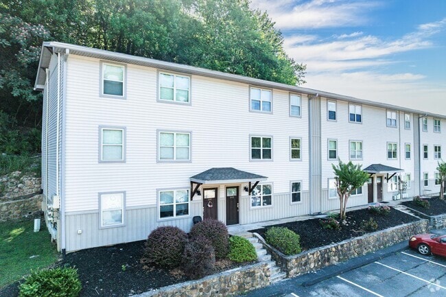
621 Memorial Dr
127A-A-008
Property Of Cambridge Hamilton Llc A New
Multifamilydwelling
NORTHSHORE VILLAGE APARTMENTS 225 UNITS
X
Hamilton
47065C0333G
Tennessee
2024
12.87 AC
2024
Stuart Heights
010502
Chattanooga
4,610 SF
Chattanooga, TN-GA
DEMOGRAPHICS near 621 Memorial Dr
1 Mile
3 Mile
5 Mile
2024 Total Population
7,285
43,768
109,224
2029 Population
7,772
46,967
117,631
Pop Growth 2024-2029
+ 6.68%
+ 7.31%
+ 7.70%
Average Age
37
39
39
2024 Total Households
3,528
20,639
48,279
HH Growth 2024-2029
+ 6.80%
+ 7.70%
+ 8.09%
Median Household Inc
$63,016
$67,627
$55,291
Avg Household Size
2.00
2.00
2.10
2024 Avg HH Vehicles
2.00
2.00
2.00
Median Home Value
$292,756
$282,426
$264,085
Median Year Built
1970
1975
1973
Nearby Places
Map Layers
Map Styles
 Street
 Aerial
- Restaurants
- Banks
- Shops
- Fitness
- Groceries
PUBLIC TRANSPORTATION
AIRPORT
Lovell Field
DRIVE
WALK
Distance
Lovell Field
28 min
12.4 mi
Freight Ports
Georgia Ports - Savannah
DRIVE
WALK
Distance
Georgia Ports - Savannah
420 min
370.3 mi
Nearby Properties
Address
Land Use
TOTAL SIZE
Lot Size
Zoning
Address
Land Use
TOTAL SIZE
Lot Size
Zoning
1,750,017 SF
31.32 AC
Address
Land Use
TOTAL SIZE
Lot Size
Zoning
603,035 SF
21.57 AC
C3
Address
Land Use
TOTAL SIZE
Lot Size
Zoning
308,910 SF
53.60 AC
M1
Address
Land Use
TOTAL SIZE
Lot Size
Zoning
6.35 AC
Address
Land Use
TOTAL SIZE
Lot Size
Zoning
409,451 SF
2.53 AC
C3
Address
Land Use
TOTAL SIZE
Lot Size
Zoning
552,237 SF
1.87 AC
Address
Land Use
TOTAL SIZE
Lot Size
Zoning
91,908 SF
2.64 AC
C3
Address
Land Use
TOTAL SIZE
Lot Size
Zoning
22.44 AC
M1
Address
Land Use
TOTAL SIZE
Lot Size
Zoning
105,125 SF
3.38 AC
Address
Land Use
TOTAL SIZE
Lot Size
Zoning
96,222 SF
0.57 AC
C3
Address
Land Use
TOTAL SIZE
Lot Size
Zoning
351,776 SF
17.70 AC
R4
Address
Land Use
TOTAL SIZE
Lot Size
Zoning
8.18 AC
9999
Address
Land Use
TOTAL SIZE
Lot Size
Zoning
275,364 SF
16.86 AC
C2
Address
Land Use
TOTAL SIZE
Lot Size
Zoning
75,697 SF
1.33 AC
Address
Land Use
TOTAL SIZE
Lot Size
Zoning
432,056 SF
2.54 AC
C3
Address
Land Use
TOTAL SIZE
Lot Size
Zoning
171,906 SF
2.10 AC
C2
Address
Land Use
TOTAL SIZE
Lot Size
Zoning
4.70 AC
9999
Address
Land Use
TOTAL SIZE
Lot Size
Zoning
49,694 SF
1.24 AC
C3
Address
Land Use
TOTAL SIZE
Lot Size
Zoning
269,640 SF
15 AC
R1
Address
Land Use
TOTAL SIZE
Lot Size
Zoning
1,617 SF
43.30 AC
R1
Address
Land Use
TOTAL SIZE
Lot Size
Zoning
157,069 SF
0.99 AC
C3
Address
Land Use
TOTAL SIZE
Lot Size
Zoning
3,810 SF
56.70 AC
Address
Land Use
TOTAL SIZE
Lot Size
Zoning
247,800 SF
1.19 AC
C3
Address
Land Use
TOTAL SIZE
Lot Size
Zoning
201,530 SF
2.45 AC
C3
Address
Land Use
TOTAL SIZE
Lot Size
Zoning
134,901 SF
1.06 AC
C3
Address
Land Use
TOTAL SIZE
Lot Size
Zoning
1,258 SF
17.78 AC
R1
Address
Land Use
TOTAL SIZE
Lot Size
Zoning
6,384 SF
12 AC
R3
Address
Land Use
TOTAL SIZE
Lot Size
Zoning
116,490 SF
2.75 AC
9999
Address
Land Use
TOTAL SIZE
Lot Size
Zoning
15,570 SF
46.17 AC
R1
Address
Land Use
TOTAL SIZE
Lot Size
Zoning
8.10 AC
The World's #1 Commercial Real Estate Marketplace
Connect with us
© 2026 CoStar Group
The information above has been obtained from sources believed reliable. While we do not doubt its accuracy we have not verified it and make no guarantee, warranty or representation about it. It is your responsibility to independently confirm its accuracy and completeness. Any projections, opinions, assumptions, or estimates used are for example only and do not represent the current or future performance of the property. The value of this transaction to you depends on tax and other factors which should be evaluated by your tax, financial, and legal advisors. You and your advisors should conduct a careful, independent investigation of the property to determine to your satisfaction the suitability of the property for your needs.